Low Altitude Flight Planning
As the lead designer for ForeFlight's Profile Corridor feature, my goal was to enhance pilots' situational awareness and improve flight safety by providing detailed visualizations of nearby obstacles along their route of flight. Profile Corridor, introduced in version 15.4 of ForeFlight Mobile, aimed to empower pilots with critical terrain and obstacle information, thereby enabling informed decision-making during flight planning and in-flight navigation.
Step 1: Understanding User Needs
To start, we conducted user research focused on pilots and navigation experts who rely on real-time hazard data. Our goal was to understand how they interpret hazard alerts, their pain points when evaluating altitude and obstacle information, and their preferences for visualizing route hazards. Key insights highlighted that users needed:
An intuitive, at-a-glance view of high-risk terrain and obstacles.
A simplified way to check hazard elevations against their current or planned altitude.
Flexibility to adjust corridor settings for custom hazard visualization.
Through user research, including interviews, surveys, and usability testing, we identified the following key needs:
-
Pilots require clear visibility of terrain and obstacles along their route to anticipate potential hazards.
-
Pilots need intuitive tools that enable quick and informed decision-making during preflight planning and inflight navigation.
-
Users seek flexibility to tailor visualizations based on personal preferences and flight conditions.
-
Seamless integration with existing ForeFlight features to ensure a cohesive user experience.
Step 2: Define Feature Scope and User Flows
Based on insights from our research, we defined the Profile Corridor feature’s core functions:
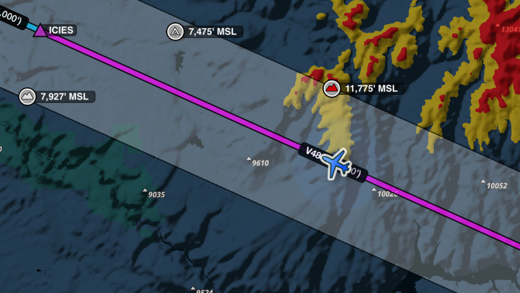
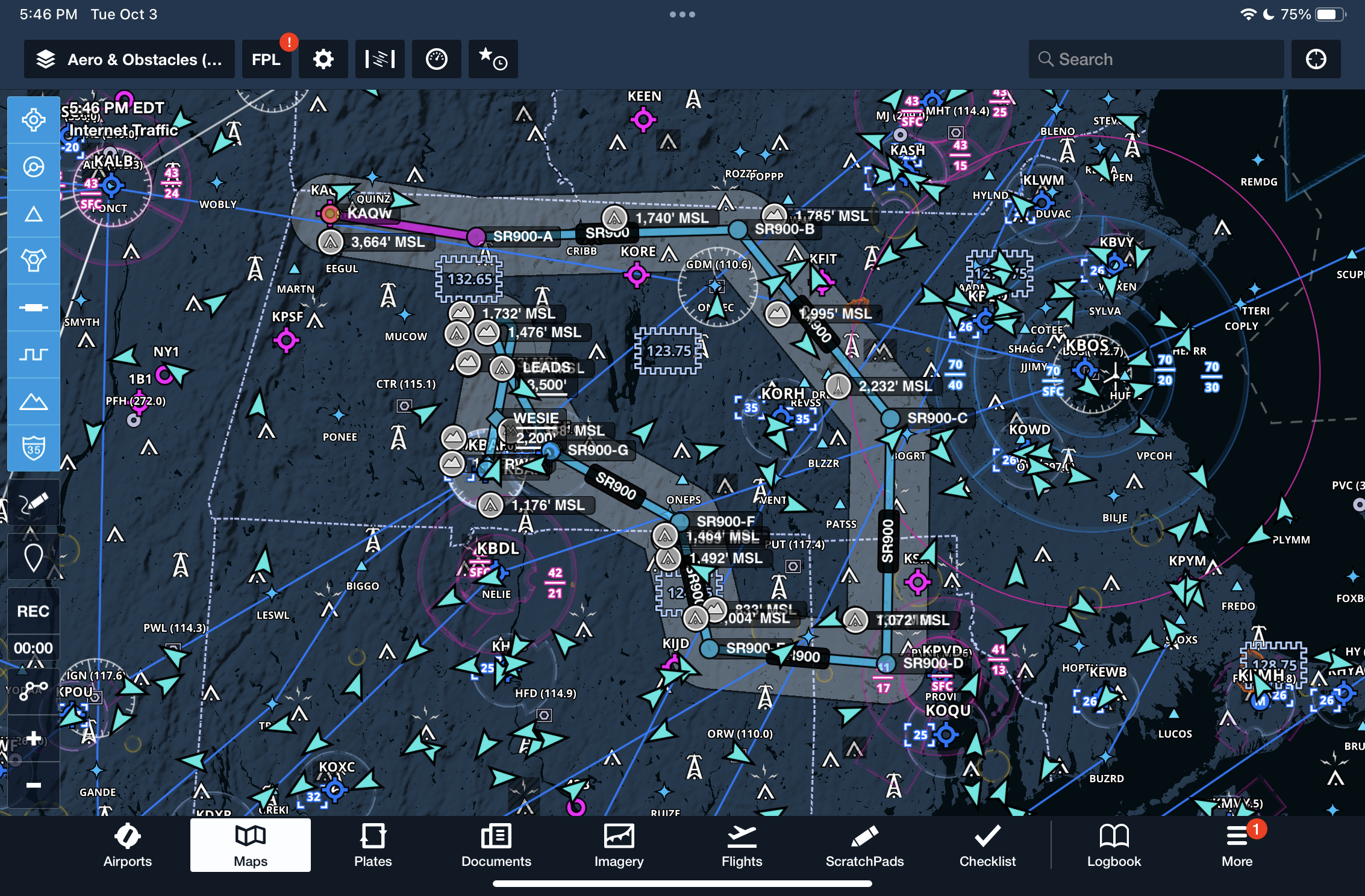
Visualization of hazards: Showing highest obstacles and terrain within a corridor around the route.
Dynamic hazard alerting: Using color-coded markers to indicate proximity of hazards relative to altitude.
Interactive route inspection: Allowing users to tap on route legs for specific obstacle and terrain elevations.
Customizable settings: Letting users adjust altitude thresholds and corridor width to suit their flight plans.
To find a cohesive user-flown, we began by mapping out each step users would take to enable and interact with the Profile Corridor feature, identifying key entry points and actions within Profile View and Hazard Advisor. They then conducted usability testing to observe how users interact with hazard markers, customize altitude settings, and interpret color-coded indicators, focusing on any pain points or areas of confusion. Finally, the we iteratively refined the flow based on feedback, ensuring a seamless, intuitive experience that aligns with user safety needs in route planning.
Step 3: Design Prototyping and User Testing
In this phase, we created high-fidelity prototypes focusing on seamless interactions and easy-to-read visuals. We paid close attention to the placement of color-coded markers, making them prominent but non-intrusive for quick hazard assessment.
Testing if users could quickly identify red and yellow hazards.
Evaluating the usability of the tap-to-inspect feature on each route leg.
Observing how intuitively users could adjust corridor width and hazard altitude settings.
Findings from testing showed that users easily identified hazards, but preferred larger tap areas on route legs for quicker access to elevation details. Additionally, we found that users wanted hazard altitude customization directly on the map screen, which informed our settings placement.
Step 4: Iteration and Refinement
Based on testing insights, we iterated on the following areas:
Enhanced tap targets: Increased the interactive area around each route leg for easier access to detailed hazard information.
Simplified settings access: Placed the hazard altitude and corridor width settings directly within the Profile View and Hazard Advisor map legend, eliminating the need to navigate to separate settings screens.
Dynamic feedback for altitude changes: Added real-time color adjustments for markers in response to changes in the Hazard Advisor Altitude Slider.
Step 5: Final Testing and Launch Preparation
In the final stage, we conducted scenario-based testing to evaluate the feature in simulated in-flight conditions. Users tested dynamic hazard adjustments by changing altitudes and inspecting corridor settings in different scenarios. This phase confirmed that:
Color-coded markers effectively communicated hazard elevations relative to altitude.
Settings customization was quick and accessible, meeting the needs of users who preferred to tailor their corridor view on-the-go.
With these validations, we finalized the Profile Corridor feature for deployment, ensuring it met the needs of Pro Plus users and provided a streamlined hazard awareness experience.
Prototype and Testing
A prototype was developed based on the design solution and tested with pilots and aviation professionals. Feedback was collected regarding usability, clarity of information, and customization options. Iterative improvements were made based on user input.
Key Features and Functionality
Profile Corridor offers the following key features to enhance the user experience:
Dynamic Visualization: The corridor dynamically adjusts based on altitude changes, providing a clear visual representation of nearby obstacles along each leg of the route.
Customization Options: Pilots can customize the corridor width and activation settings to suit their preferences and flight conditions, enhancing flexibility and control.
Intuitive Interaction: Interacting with Profile Corridor is intuitive, allowing pilots to tap on any leg of their route to view detailed elevation information of the highest obstacle and terrain feature.
Seamless Integration: Profile Corridor seamlessly integrates with Hazard Advisor and other ForeFlight features, offering a cohesive user experience across the platform.
Implementation
Profile Corridor was integrated into ForeFlight's latest release, following thorough testing and refinement. User documentation and tutorials were provided to ensure seamless adoption by pilots and flight departments.
Evaluation
Post-release feedback and user analytics were collected to evaluate the effectiveness of Profile Corridor in enhancing situational awareness and navigation safety. Iterative updates will be made based on user feedback to continuously improve the feature.

Conclusion
Profile Corridor in ForeFlight Mobile represents a significant advancement in enhancing flight safety and situational awareness for pilots. By providing detailed visualizations of terrain and obstacles along the route of flight, Profile Corridor empowers pilots with critical information to make informed decisions and mitigate risks effectively. As the lead designer on this project, I am proud to have contributed to the development of a feature that prioritizes user needs and elevates the overall user experience within ForeFlight.


